With so many DJI drone autopilot apps on the market, it can be difficult to pick the best one for your mapping needs. Our goal is to review the differences between apps, and how they impact the user. Autopilot Apps will all collect photos for drone mapping but, there are subtle and occasionally, major differences, that can make or break an app.
Why do you need an Autopilot app?
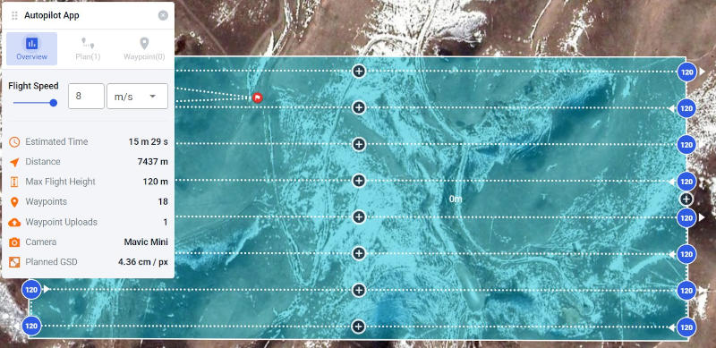
If you’re planning on mapping with your drone, you’ll want to use one of the best DJI apps available. An app allows you to draw a boundary around the area you want to map, additionally, within the app, you can change settings such as: flight altitude, imagery overlap and camera angle. If you are unfamiliar with these concepts, please check out our article on how to make great maps.
After planning the flight, an app will have the drone automatically: take off, collect images, return to the take off point, and land itself. Once your flight is complete, you can upload the images to Civil Tracker for processing. Then you can start mapping, measuring and creating a virtual survey.
In short, it takes three things to start mapping.
- A drone
- An autopilot app
- Mapping software such as Civil Tracker
Rating Factors
When choosing an app, there are so many factors to evaluate and consider, a large number of which are personal and subjective. Following are the criteria that are most important in making a wise decision.
Drone Compatibility
How many different drones is the app compatible with? Many of these DJI drone autopilot apps are not compatible with the Mini series of drones, limiting their overall functionality for many customers. Most importantly, is the app compatible with your drone?
Device Compatibility
How many different devices is the app compatible with? Many DJI drone autopilot apps work with both Android and iOS. Apps were given full marks when they worked with both devices.
Ease of use
How easy is it to get out and start mapping? For example, some apps have the ability to plan flights in a web browser on a computer and in the app on your device. This provides more flexibility and overall ease of use.
Cost
The apps on this list vary from being completely free, to expensive monthly subscriptions. For those just starting out, or the hobbyist mappers, low cost or free options are an obvious advantage. However, for an advanced drone LiDAR operation, paying $99 a month for UgCS is well worth the cost.
Best DJI Drone Autopilot Apps
In our review of the top 9 apps, they are listed from high to low. Check out the following ratings and descriptions to find the app that best suites your needs.
| Autopilot App | Rating | Excels At |
|---|---|---|
| DJI Pilot | Best Overall DJI Drone Autopilot App | |
| Dronelink | Best for Mini 2 and Mini SE | |
| Drone Harmony | Most Flexible DJI Drone Autopilot App For Mavic Mini | |
| Copterus |  | Best iOS Mavic Mini Autopilot App |
| Drone Deploy | | |
| Pix4D Capture | | |
| DJI GSP | Best DJI Drone Autopilot App For iPads | |
| UgCS for DJI | LiDAR | |
| Map Pilot |
Now, we’ll dive in for a deeper look at each app individually. Keep reading below to learn more about each app, and figure out which is the best fit for you.
DJI Pilot
![]()

We started with apps made by DJI. There are definite advantages to using an app made by the drone manufacturer. They integrate better, don’t raise questions about the drone warranty, and help avoid switching between two apps. When using a non DJI autopilot app, we recommend using the primary DJI flight app (usually DJI Fly or DJI Go4) to perform pre-flight inspection, calibration and a short manual flight before switching to the autopilot app. DJI’s own apps are the most reliable for updating firmware, completing the compass calibration and checking the overall status of the drone.
DJI Pilot was made with their enterprise drones in mind. It works with the Phantom, Matrice and some of the Mavic series drones. A total of 15 different models at last count. Key for many users is that it does NOT work with the Mavic Mini or Mavic Air series drones.
DJI Pilot comes in both an Android and Apple version. This is really handy. I often recommend an app to a client only to find out they don’t have iOS or vice versa.
Pros
- Free
- Made by DJI
- Compatible with with many different drones
- Compatible with both iOS Devices and Android devices
- Simple to use
Cons
- No virtual stick control
- No Mavic Mini, Mini 2, Mini SE or Mavic Air 2 support
Dronelink
![]()

Dronelink is the second non DJI app we’ll review, it is an extremely powerful autopilot app, with more functionality than any other on this list. Yet, even with all that power, it’s fairly easy to use, set up basic mapping and collect data.
Dronelink has the most comprehensive support for the Mini series of drones including both Android and iOS support for all three mini drones.
Pros
- Dronelink is powerful
- Compatible across both Android and iOS.
- Compatible with many versions of DJI drones including the Mavic Mini 2, Mini SE and Mavic Air with Virtual Sticks
- Includes Terrain following
- Works with Smart controllers and CrystalSky
Cons
- Most expensive mapping only app.
- Details can be overwhelming and complicated
Drone Harmony
![]()

Drone Harmony specializes in 3D inspections and site imagery. Drone Harmony and Dronelink are closely related in this aspect. They both do an excellent job at mapping, but mapping is only a fraction of what the apps are capable of.
While Drone Harmony doesn’t advertise a free version on their website, there are certain functions that are included for free. This makes Drone Harmony very appealing for basic mapping operations.
The main mapping operation that needs to be paid for is terrain following. Planning a map with Drone Harmony takes a few more steps than several other apps. But, you get the same end result. Drone harmony has a complete compatibility list on their site.
Pros
- Free version for mapping
- Drone Harmony is powerful and versatile
- Compatible across both Android and iOS.
- Compatible with many versions of DJI drones including the Mavic Mini and Mavic Air with Virtual Sticks.
- Custom terrain following
Cons
- More steps to plan a mapping flight than most apps
- Mini / Mini 2 / Mini SE only work on Android
Copterus

It’s exciting to see new autopilot apps continue to arrive. This brand new iOS only mapping app was launched in 2020. The simple and intuitive user interface allows for quick flight planning. This simple, effective app is definitely a great option for the iOS user.
Pros
- Cheap at only $4.99
- Compatible with many versions of DJI drones including the Mavic Mini and Mavic Air with Virtual Sticks
- No logins, signups or subscriptions. Just download and start mapping.
Cons
- No Mini 2 or Mini SE Support
- No Android version
- No terrain following
Drone Deploy

Drone Deploy mapping app works well, is intuitive and easy to use.
Pros
- Simple to use
- Terrain following
- Works on Anroid and iOS
Cons
- No virtual stick control
- No Mavic Mini support
- Expensive starting at $99/mo
Pix4D Capture

Drone Deploy mapping app works well, is intuitive and easy to use.
Pros
- Simple to use
- Works on Android and iOS
Cons
- No virtual stickNo virtual stick control
- No Mavic Mini or Mavic Air support
- Expensive, starting at $165/mo
- No Terrain Aware
DJI Ground Station Pro (GSP)
![]()

DJI GSP is the second DJI made app we’ll look at. Again we like the fact that it is made by DJI. GSP is a fantastic app for quickly making flight plans. It gives full control over the little nuances such as flight speed, camera angle etc.
The main drawback of GSP is that it is designed for the iOS iPad. This really limits who can use the app. However, if you’re already using an iPad, I highly recommend giving GSP a try.
It’s free and works well for anyone with an iPad.
Pros
- Made by DJI
- Compatible with with many different drones
- Simple to use
- Free
Cons
- Only compatible with iOS iPad
- No virtual stick control
- No Mavic Mini, Mini 2, Mini SE or Mavic Air 2 support
UgCS
![]()

UgCS is much more than just a mapping autopilot app. For mapping however it is a very powerful tool including supporting multiple drones, terrain following and immersive 3D planning. However, there is a learning curve and the typical setup requires using both a laptop and a phone or tablet device. This is atypical and is not something everyone will find convenient or possible
Pros
- Multi drone / swarm capable
- Powerful for other remote sensing applications such as LiDAR, Ground penetrating radar and other sensors
- Compatible across both Android and iOS.
- Has custom terrain following
Cons
- No virtual sticks
- Pricing starts at $39/mo and goes up to $99/mo.
- Steep learning curve
- Complex setup
- No virtual stick control
- No Mavic Mini, Mini 2, Mini SE or Mavic Air 2 support
.
Map Pilot
![]()

Map Pilot by Maps Made Easy has long been a fan favorite for its ease of use and terrain following. The app works well for collecting high quality data on iOS devices.
Pros
- Simple to use
- Terrain following
- Starts at $5/mo
Cons
- No Virtual Stick Support
- No Mavic Mini, Mini 2, Mini SE or Mavic Air 2 support
- No Android support Only iOS compatible
Still Need a Drone for Mapping?
We’re guessing that you probably already have a drone if you’ve gotten this far. But if you’re still trying to decide what drone to use for mapping we have two standard recommendations. For most people the DJI Phantom 4 Pro V2 is the way to go. It has an excellent camera, it’s a proven and robust platform, and it’s affordable. If you’re looking to map with a micro drone at less than 0.55lb /250g, then the Mavic Mini 2 or Mini SE are the only suitable drones on the market.
Processing your images
Once you’ve used your drone and autopilot to collect images, sign up for Civil Tracker and upload your images to our processing engine. Civil Tracker does the heavy lifting of processing hundreds of images into a true orthophoto and terrain model. Allowing you to achieve our goal of visualizing and measuring your mapping area of interest.
Conclusion
What do you think is the best DJI drone autopilot? We’d love to know what you think. Add a comment below or send us an email.