Leading Drone Software for Aggregates
Decrease costs while improving accuracy, speed and safety
Drone Software for Aggregates: Sand and Gravel
Civil Tracker is a leading drone mapping and survey solution. We support you by bringing together 15 years of survey experience, thousands of drone flights, and our Civil Tracker software. It has never been so easy and cost effective to start using drones for aggregate sand and gravel industries.
We know how many steps and challenges exist in the aggregate business. Whether figuring out how much overburden is left or knowing exactly how much product is available, Civil Tracker gives you the insights to manage your operation efficiently.

Speed

Survey 10 times faster than GPS. Get results in hours, not days.
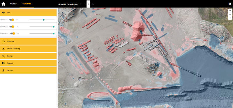
Gravel Pit Management

Aggregate clients are using Civil Tracker to manage pit operations and yard inventories. First, track topsoil and overburden removal in advance of crushing. Then measure pit extraction and material yields during crushing operations. Never crush too much or too little again.
Aggregate Inventory
Tracking inventory, movement, and use through the year is simple with Civil Tracker. All location and stockpile quantities are secure and central on our cloud.
Improving Safety

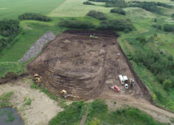
Drone maps provide early detection of safety hazards. Use the map to train new workers or provide directions to truck drivers. Reduce the risk of surveying and allow your team to fly stockpiles and pits, with no risk of injury.
Environmental
Gravel companies achieve early identification of issues such as groundwater ponding and erosion.
Case Study
Camrose County started using Civil Tracker in 2020. Enabling them to track all stages of their annual crushing operation and monitor inventories throughout the county.
Before switching to Civil Tracker county staff would either have to climb the stockpiles, a time-consuming and sometimes dangerous job, or outsource their drone surveys. This meant infrequent access to information.
After switching to Civil Tracker, Camrose County was able to monitor the change of all stages of their operation. This removed any surprises and allowed them to crush the exact amount specified in the contract.
“Civil Tracker has reduced the amount of survey time required to survey the piles in our pit and increased the safety associated with these tasks. The support staff have been amazing to work with. I would highly recommend Civil Tracker.”
— Mark McNary
They Trust Us