Stockpile TIN Base vs. Low Point Base
When measuring stockpiles, the base plane plays a crucial role in determining the accuracy of the volume calculations. The base plane is essentially the imaginary flat surface on which the stockpile rests, and any errors in defining this plane can lead to substantial inaccuracies in the final volume measurement.
If the base plane is not correctly established, the volume calculated could either include or exclude portions of material that shouldn’t be, leading to an overestimation or underestimation of the stockpile’s size. For example, if the base plane is set too high, it might exclude some of the material at the bottom, reducing the calculated volume. Conversely, if it’s set too low, it could add extra volume that isn’t actually part of the stockpile, inflating the figures.
This issue is especially pronounced in irregularly shaped stockpiles, where the natural ground surface might not be level. Modern techniques like 3D laser scanning and photogrammetry can help in accurately defining the base plane, thereby improving the accuracy of stockpile volume calculations.
Read more about how we use volume of regular shapes to calculate volumes of irregular ones
http://www.math-mate.com/chapter28_1.shtml
Precision in stockpile measurements is critical, particularly in industries where even small discrepancies can have significant financial and operational impacts. By using advanced algorithms that consistently apply a standardized set of rules, you ensure that the millions of surface data points are accurately sampled and analyzed. This approach eliminates the subjectivity and potential errors that can arise from relying on gut feelings or rough estimates.
Civil Tracker algorithms are designed to handle the complexities of irregularly shaped stockpiles, variations in material density, and the intricacies of the terrain. By doing so, they provide reliable and precise volume measurements, enabling better decision-making, inventory management, and financial forecasting. Precision in this context isn’t just about getting a closer number—it’s about ensuring that every calculation is trustworthy, reproducible, and actionable.
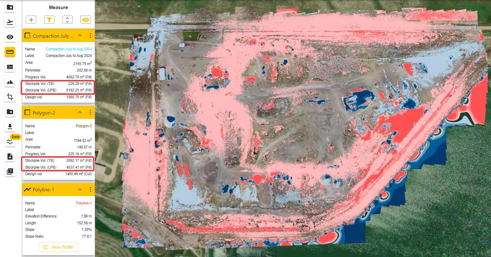
Civil Tracker calculates volumes using two different algorithms for pile base interpolation. Both of these algorithms yield very different values and the use may vary depending upon the placement of the pile itself.
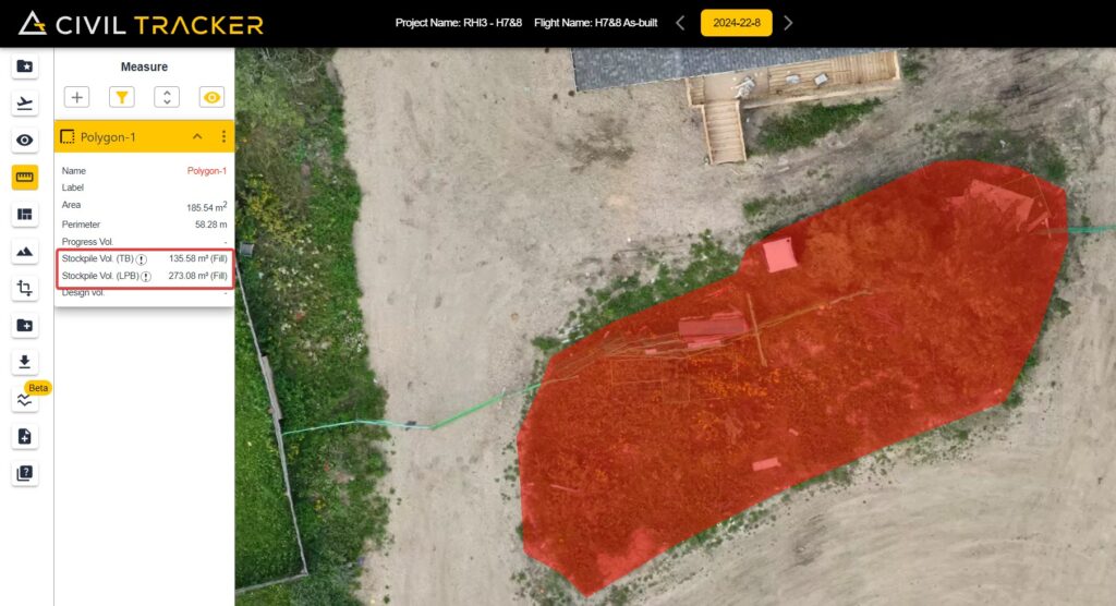
Stockpile Volume TIN
Civil Tracker’s approach of using a TIN (Triangulated Irregular Network) surface for volume calculations is a powerful method for stockpiles. By taking the elevations of all the nodes within a defined polygon, Civil Tracker generates a TIN surface that accurately represents the terrain or base surface. This TIN surface acts as a reference point for comparing the actual terrain captured by drone surveys.
Once the drone captures the terrain surface data, it’s overlaid onto the TIN surface. The software then calculates the volume of material by assessing the space between the TIN surface (interpolated from the polygon’s nodes) and the drone-derived surface. This technique ensures that the volume measurements are accurate, as it accounts for variations in the terrain and provides a detailed comparison between the planned or baseline surface and the actual surface.
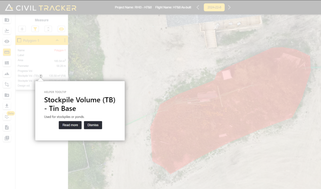
This method is especially useful for monitoring changes in stockpiles over time, allowing for precise tracking of material movement or accumulation. The combination of drone technology and TIN-based calculations ensures high accuracy and reliability, making Civil Tracker an essential tool for industries that require precise volume assessments.
Stockpile Volume Low Point
This volume calculation method is particularly effective for scenarios like piles against a slope, connected piles, or binned material, where a more straightforward approach is needed. By using the elevation of the lowest node on the polygon to establish a flat plane, the method simplifies the process of determining the base level for volume calculations.
Here’s how it works:
- Flat Plane Creation: The elevation of the lowest node in the polygon surrounding the stockpile or material is used to define a level, flat plane. This plane serves as the baseline for the volume calculation.
- Surface Comparison: The drone terrain surface, which accurately captures the shape and elevation of the pile or material, is then compared against this flat plane.
- Volume Calculation: The volume is calculated as the difference between the drone-derived terrain surface and the low point plane. This approach effectively measures the volume of material above this baseline plane, regardless of the slope or the irregularities of the terrain.
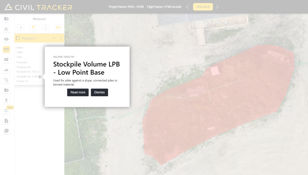
This method is particularly useful in complex environments where materials are piled against slopes, where piles are interconnected, or where materials are stored in bins. By using the lowest point as a consistent reference, this technique helps ensure that the calculated volumes are accurate, even in challenging conditions where traditional methods might struggle to provide reliable results.
Read more
Hill Plain’s Pioneering Journey with Civil Tracker