
Previously in Can I Map and Survey with the Mavic Mini we showed an accuracy study, but we wanted to follow up with more. Why you ask? As you know, our nature is to push the limits with affordable lightweight drones. And this means that it’s important to keep testing the reliability and accuracy of the results. We suspect we’re not the only ones wondering just how accurate is mapping with the DJI Mavic Mini when paired with Civil Tracker?
In this blog we will look at two tests. First we compare DJI Mavic Mini results to RTK GPS and second we compare the DJI Mavic Mini with the DJI Phantom 4 Pro.
Mavic Mini vs GPS Checkpoints
In our first test we compare the vertical accuracy of the drone results with RTK GPS checkpoints. RTK GPS is very reliable and has an accuracy of about 2.5 cm (1″). This is a common way of checking drone accuracy.
The County of Lac La Biche completed their volume survey at one of their landfills. After surveying the GCPs the field team collected 24 random elevation points. It’s important to note that the check points are independent of the Ground Control Points.
We processed Mavic Mini images and the GCPs in Civil Tracker. After which we compared the RTK GPS check point elevations with the drone survey elevation. I have plotted the check points and colored them by the difference in elevation.
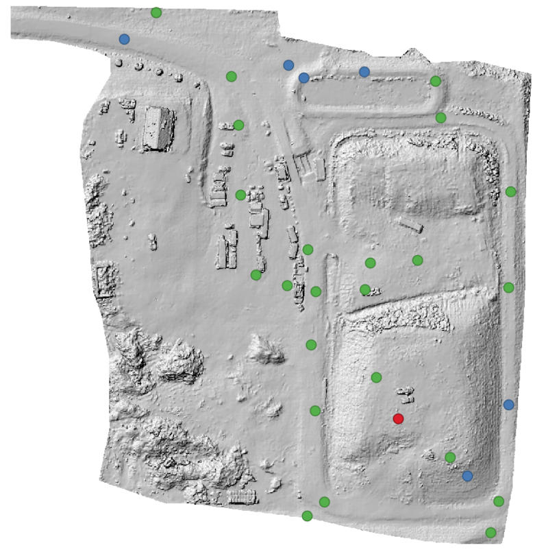
In the image above green points are within 5 cm (2″). Next, blue points are within 10 cm and finally the single red point has a difference greater than 10 cm.
The mean difference was -1.4 cm and the RMSE was 4.8 cm. These results where better than expected and provided the landfill operator with great confidence in the drone mapping.
Landfill Flight Details.
The flight parameters were 75% front overlap, 75% side overlap. The drone was flown 75 m (246 ft) above ground level yielding a ground sample distance of 2.7 cm (1.1″). Finally, the camera pointed straight down at -90° and flight speed was set for 30 kmh (19 mph). The field team surveyed checkpoints using an Emlid Reach RS2 RTK GPS.
Mavic Mini vs. Phantom 4 Pro
Our second test compared the surfaces from two different drones directly against each other. This does not give us a quantitative accuracy result. However, it helps us understand what to expect from the Mavic Mini.
Wetaskiwin County flew their Mavic Mini and their Phantom 4 Pro over the same gravel stockpile. The goal was to compare the volumetric results of the data from the two datasets. We processed both flights using identical GCPs in Civil Tracker.
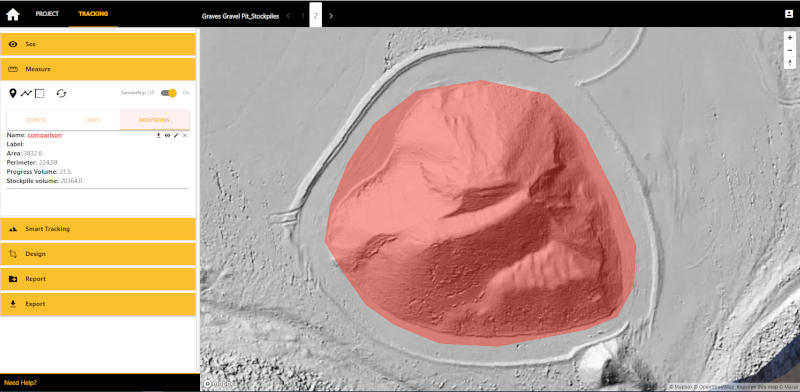
We then compared both surfaces using Civil Tracker’s cut-fill functionality. The volume difference between the two flights was 21 cubic meters (25 cubic yards). The difference was over an area of 3,832 square meters (41,000 square feet). This creates an average elevation difference of 5.6mm (1/4″).
The stockpile volume was 20,364 cubic meters and the difference in volume between the two flights was 0.1%. The results gave the Public Works team confidence to use the Mavic Mini and Civil Tracker for quantity surveys.
Mavic Mini Flight Details.
The flight parameters were 75% front overlap, 75% side overlap. The drone was flown 75 m (246 ft) above ground level yielding a ground sample distance of 2.7 cm (1.1″). Finally, the camera point straight downward at -90° and flight speed was set for 25 kmh (16 mph). The field team surveyed GCPs using a Trimble GPS receiver.
Phantom 4 Pro Flight Details
The flight parameters were 75% front overlap, 75% side overlap. The drone was flown with ground sample distance of 1.5 cm (0.6″). Finally, the camera was oblique at -70° and flight speed was set at high.
How Accurate is Mapping with the DJI Mavic Mini?
Our tests show that with proper flight parameters, ground control points and processing software that an accuracy of 5 cm can be achieved. Tests show that stockpile volumes derived from the Mavic Mini are very comparable to the Phantom 4 Pro.
Test for Yourself
Every aspiring drone surveyor should do their own tests. These test are important to develop confidence in both the drone and processing software.
Not all photogrammetry applications will generate accurate results. It’s critical to only use quality photogrammetry software for high accuracy applications.
Next Steps
If you need tools for processing and visualization Civil Tracker provides a free trial to all new users who sign-up.
If you’re not quite sure what to do next, we’d love to connect and guide you on your drone mapping journey.
At Civil Tracker we’re working with our clients to build trust in drone data. We also provide coaching on how to get the best results. We thought you might appreciate learning from some of our test results. And how we achieved those results.