Skip to content
Civil Tracker
  • IndustriesExpand
    • Landfills and Waste Management
    • Aggregate Sand and Gravel
    • Municipal Services
    • Mining
  • ProductsExpand
    • How Civil Tracker Works
    • Ground Control Points as a Service
  • LearnExpand
    • Our Insights
    • Our Expertise
    • Our Technology
    • Support
  • Pricing
  • Contact
  • Login
  • Sign Up
Civil Tracker

Cut Fill

Civil Design Surface Cut Fill
Monitoring | Reporting | Support | Waste Management

Civil Design Surface Cut Fill

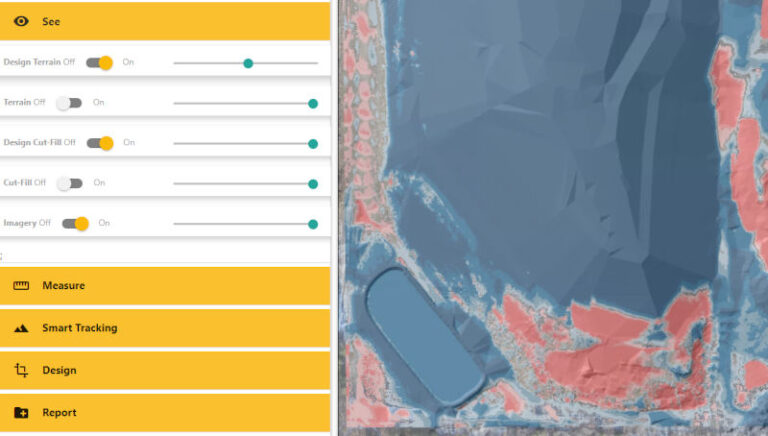
Compare your drone survey with your civil design surface to find cut and fill elevations and volumes One key to effective construction and site management is the ability to accurately know how much work is…

Read More Civil Design Surface Cut FillContinue


Categories
  • Client Stories (4)
  • Drone (11)
  • Getting Started (5)
  • InTheNews (1)
  • Monitoring (7)
  • Regulatory (7)
  • Reporting (9)
  • ROI (5)
  • Support (9)
  • Survey (16)
  • Training (13)
  • Video (4)
  • Waste Management (3)

Does your surveyor have this view of your earthworks project? Now they can
Twitter Linkedin

© 2025 Civil Tracker

  • Privacy
  • Terms and Conditions
  • Industries
    • Landfills and Waste Management
    • Aggregate Sand and Gravel
    • Municipal Services
    • Mining
  • Products
    • How Civil Tracker Works
    • Ground Control Points as a Service
  • Learn
    • Our Insights
    • Our Expertise
    • Our Technology
    • Support
  • Pricing
  • Contact
  • Login
  • Sign Up
Twitter Linkedin