
Drone LiDAR
Drone LiDAR has become the standard drone mapping solution when vegetation is present. It allows for accurate ground mapping through grass, shrubs, and trees. Rapid deployment and data processing may be the right data source for your project needs. You likely have several great questions if you’re like many of the people I’ve worked with.
- What is LiDAR?
- What is Drone LiDAR?
- How Accurate is Drone LiDAR?
- How do I use the data?
- What types of projects is Drone LiDAR right for?
Want to learn more? Keep reading.
What is LiDAR?
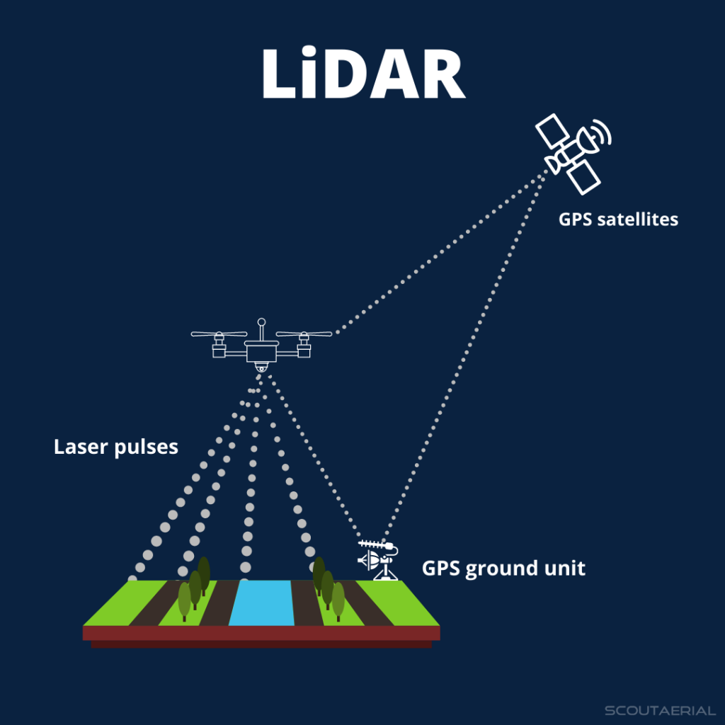
LiDAR stands for Light Distance and Ranging. A laser (the light source) is emitted, and the distance to the ground can be calculated by measuring the amount of time it takes the light to travel to the ground and back to the sensor. When the location of the light source and the orientation of the laser are known, the position on the ground can be determined. LiDAR can accomplish this by putting everything together and doing it a million times a second.
 |  |
What is Drone LiDAR?
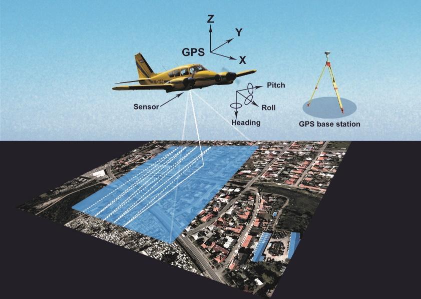
Originally, LiDAR was done from above in an airplane or helicopter and on the ground from a tripod or moving vehicle. In the last several years, the technology has (advanced and is now small enough to)/ been miniaturized enough to be put on drones. This allows for small and remote areas to be efficiently and cost-effectively mapped and surveyed by a survey crew.
How does Drone LiDAR differ from Drone Photogrammetry?
Drone photogrammetry, or drone mapping and surveying, uses a digital camera. Hundreds or thousands of images are taken with the camera and then stitched together into a 3D model. They are digitally replicating what our eyes and brain do when we perceive depth from our left and right eye or when we inspect an object by looking at it from different angles.
Compared to LiDAR, photogrammetry systems may struggle to pick out very small and finely detailed objects — for instance, while LiDAR pulses can pick up power lines, the photos taken by photogrammetry modules might not detect the wires. LiDAR is also able to penetrate through vegetation to capture the shape of the underlying terrain, and it can even work in the dark.
The primary reason to choose photogrammetry has been its relative accessibility. With lighter and more affordable modules, it’s a go-to for companies that haven’t needed the extra level of precision enabled by LiDAR data. Furthermore, the software to assemble point clouds from raw photogrammetry data is more common and frequently used than the LiDAR alternative.
As the costs and weight of LiDAR come down, the math may change for some of these businesses, encouraging greater LiDAR uptake. Furthermore, it’s possible to use drone LiDAR alongside other mapping methods to create more detailed models overall. This is important in cases when the finished product must be photo-realistic, because, as noted, LiDAR pulses don’t capture the colors of objects.
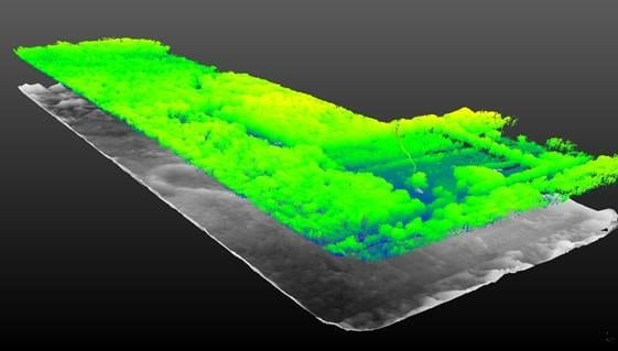
Drone photogrammetry is impressively accurate on open hard surfaces. Unfortunately, it only captures the top of what can be seen. When vegetation exists, the best photogrammetry can do is capture a noisy top of grass, bush, or tree.
How Accurate is Drone LiDAR?
There are many factors affecting the accuracy of drone LiDAR. When data is collected using best practices and post-processed by a professional team, accuracies of +/-5cm can be expected.
The data collection should include using ground control points to prove the accuracy of the data.
Processing should include strip alignment, machine learning ground classification, manual hands-on cleaning, and quality assurance.
We found a very interesting article that dives in depths of how drone LiDAR data works and how much accurate results you can gain from it. Its definitely a very worth while read!!
https://doi.org/10.3390/rs15020442
Data Density – How Much Data Will Be Collected?
Drone LiDAR is generally collected at a density greater than 100pts / m2 or more than 10pts/ft2. This is exponentially more data than traditional aerial LiDAR or off-the-shelf LiDAR, which are commonly used.
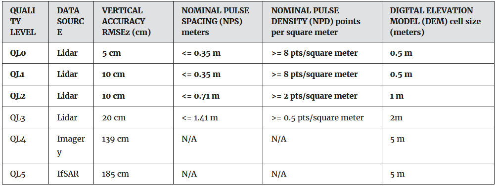
Drone LiDAR Quality
The USGS has codified multiple levels of LiDAR quality. Traditional topographic LiDAR, which can be purchased off the shelf or captured from a manned aircraft, is QL2. Drone LiDAR that is appropriately captured and processed will be QL0 or QL1.
Use Cases
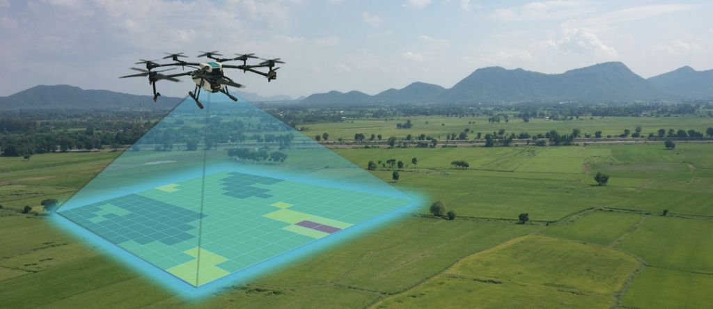
There are many different applications for Drone LiDAR. Most projects will benefit from LiDAR at various stages. Whether in planning, design, construction, or eventually when they are returned to their original state. Here are a handful of the most common uses we see for Drone LiDAR data.
Aggregate Rock, Sand and Gravel
Throughout the lifecycle of aggregates, measurements or surveying are almost constantly required. This could be to select a site for a new gravel pit, obtain permitting to extract sand, measure inventory, or confirm that all regulatory requirements have been met for abandoning a retired quarry.
Traditional aerial imagery, topographic surveys, and scale houses have been augmented or replaced by drone mapping, drone LiDAR, and digital apps.
Mining
Laser scanning has been used in mining for the last 30 years. Traditionally, it has been done using a Tripod laser Scanner (TLS) or a mobile truck-based laser scanner (MLS). Both methods produce impressively accurate 3D models of a mine site. Drone LiDAR is the latest tech evolution used to scan mines. By obtaining an aerial perspective, many of the challenges of TLS and MLS are eliminated. Using drone LiDAR, the 3D model can be generated in a more timely and cost-effective manner.

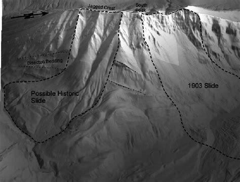
Geotechnical Geohazard Investigation
Drone LiDAR can be used to monitor ground stability, and provides an excellent topographic overview for site-based geohazard analysis. Historical slides can be found; areas can be divided into low-risk and high-risk to direct boots-on-the-ground investigation. Finally, time series analysis can be done by acquiring annual or repeated drone LiDAR to confirm if movement is happening and quantify the amount of movement.
Drone LiDAR does not replace traditional geohazard tools, such as in-person site investigation and slope inclinometers. Instead, it augments and directly complements efforts, creating a synergistic effect.
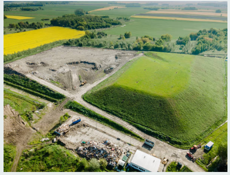
Landfill and Waste Management
Landfills must be planned, tracked and also monitored indefinitely. Drone mapping and drone LiDAR can be crucial in planning, monitoring, and determining elevations, particularly when vegetation exists, during active operations.
Pipeline Design, Routing and Operations
Detailed topographic information is required to select a pipeline route. Once the engineering phase of the route is in progress, refined information is needed for powerline crossings, creek and river crossings, determining offsets from existing infrastructure, etc. Finally, during operations, the terrain needs to be monitored often to ensure the stability of the ground and prevent any leaks from occurring. As mentioned above, in the geohazard analysis, drone LiDAR is an essential tool for tracking changes to ground stability and conditions.
Top LiDAR drone options
With LiDAR drones becoming more widely available, technology buyers can start comparing hardware options to find the perfect UAV and sensor loadout for their purposes. The Zenmuse L1, a LiDAR sensor model available form DJI, is a valuable option for businesses due to its wide-ranging feature set, including:
- An integrated inertial measurement unit, capable of delivering survey-grade accuracy of 5cm and absolute accuracy of 10cm, all from an altitude of 50 meters.
- A 3-axis stabilized gimbal, which enables fully automatic mount control through integration with the DJI flight management system.
- A 1-inch 20MP CMOS sensor, which records photo and video data. This enables users to apply color data to LiDAR point clouds, alongside other functionality.
- Support for three returns per laser shot, delivering a greater degree of accuracy when penetrating dense foliage and measuring the topography of the land underneath.
- A non-repetitive scan mode which delivers a higher degree of resolution for data compared to a regular scan line when a drone records a single area for an extended time.
- IP54 certification, attesting that the L1 can function in adverse weather such as fog, smoke, and snow.